
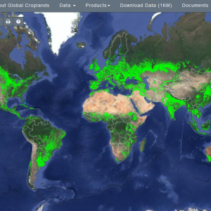
The U.S. Geological Survey (USGS) has released a worldwide map that details croplands in high resolution in an ongoing effort to monitor croplands and water use.
The Global Food Security Analysis-Support Data at 30 Meters (GFSAD30) is a NASA funded project to provide high resolution global cropland data and associated water use that contributes towards global food security in the twenty-first century. The GFSAD30 products are derived through multi-sensor remote sensing data (e.g., Landsat, MODIS, AVHRR), secondary data, and field-plot data and aim to document cropland dynamics from 1990 to 2017. The resource maps and produces cropland products of the world at a 30 meter resolution, covering:
- Cropland extent/area;
- Crop types with a focus on 8 crops that occupy 70% of the global cropland areas;
- Irrigated versus rainfed;
- Cropping intensities: single, double, triple, and continuous cropping;
- Cropland change over space and time: 1990-2017.
- Crop productivity (productivity per unit of land; kg/m2)
- Water productivity (crop per drop or productivity per unit of water; kg/m3).
You can start exploring the maps here. For coverage of some of the main findings, see here.


Post a new comment »